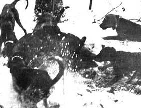
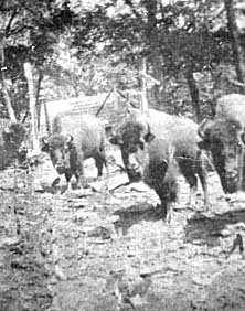
Wild boar under attack Right, buffalo roam at Hooper Bald |
 |
| Back to the Index | WILDLIFE AND FOREST RESOURCES IN GRAHAM COUNTY | Back to the Index |
Graham County has, since its conception, been known as a land teeming with wildlife of considerable variety. Its citizens have ever been eager to defend and promote its wildlife status against those who would trample and destroy its game yet ever eager to enjoy hunting and fishing to the fullest.
One of the strangest dwellers of the Snowbird Mountains is none other than the wild boar that first arrived in this area during the early years of the twentieth century. These creatures are known as "rooshians" based on the theory that they originally came from Russia. From physical similarities they would seem to be descendants of the "wildschwein" (wild pig) from the Harz Mountains of Germany.
Biologists and park rangers denounce the boars for their unsavory habits of uprooting grassy uplands, destroying azalea groves, killing snakes and smaller animals, and competing with the black bear for food. Though unwelcome by the science-oriented naturalist, the wild boar is popular among the hunters. Having adapted well to the wilderness area, they thrive and prosper in the mountains between Robbinsville and Tellico Plains. Whether considered a nuisance or a blessing, the wild boar has established itself as an integral part of the wildlife of this area. Endowed with the natural savage spirit, the boar has unique speed, stamina, and agility. It is said the boar can jump a 15 or 20 feet obstacle and be making full speed when he hits the ground. His facial features and razor sharp tusks make him a most frightening sight to behold. Many a hunting dog has learned the versatility of the boar in a very painful way. The boar often stands three feet high and weighs between two and four hundred pounds.
|
Wild boar under attack Right, buffalo roam at Hooper Bald |
|
The idea of importing the wild boar to North Carolina and Graham County in particular was first conceived in 1908. In that same year, the Great Smoky Mountain Land and Timber Company sold an expansive tract of land to the Whiting Manufacturing Company. George Gordon Moore of St. Clair, Michigan was an agent for Whiting. During the above-mentioned transaction, Moore was given 1600 acres of mountain land on which to establish a European type shooting preserve for the entertainment of wealthy clients and friends. Moore selected for his location a remote section of the Snowbird known as Hooper Bald. Hooper Bald is 5429 feet high and lies in proximity of Haw Knob, Stratton Meadows, Laurel Top, and Swan Meadows.
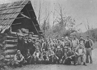
Three years were spent in preparation before the operation could begin. No small task was the construction of a road to the Bald. The road could be used by the ox wagons, but it was always necessary to have from one to three teams of oxen attached to each wagon depending on the load it was carrying. In later years the Hooper Bald area was accessible by jeep only, but today the Cherohala highway runs right past it. A clubhouse was constructed of logs, 90 feet long and 40 feet wide, containing 10 bedrooms, two baths, a kitchen and dining room. The lobby was 45 x 20 feet. The lower house was a caretaker's home - a four-room cabin with a porch all the way around it. Telephone lines were strung across the Snowbird Mountains from Marble.
Huge enclosures appropriate for its various occupants were constructed including a 600-acre boar enclosure and an enclosure for buffalo over a mile in circumference. It is said that twenty-five tons of double-strand barbed wire was hauled in by wagon to fence the various game lots. The wild boar lot was built of huge chestnut rails, nine rails high.
At last, in 1912 the selected game animals began to arrive in wooden crates by railroad in Murphy and Andrews. Captain Frank Swan, a retired State Guard Cavalry Officer recalled vividly serving as master of the ox wagon train in transporting all the animals into the Hooper Bald refuge. The first animals were moved in from Murphy by wagon trail pulled by oxen over Hanging Dog Mountain. Others were moved in later from Andrews over the Snowbird-Unicoi Hardwood Railroad to Little Snowbird, then transported by ox wagon train from there to Hooper Bald. The moving process was a large-scale operation with many unique hardships extending from early spring until the close of summer.
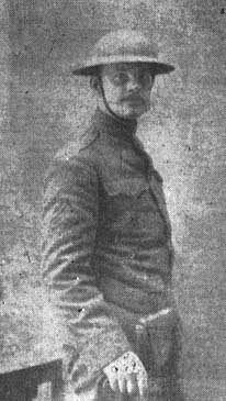
Captain Frank Swan, Wagonmaster |
Cotton McGuire, Manager of the Hooper Bald game preserve |
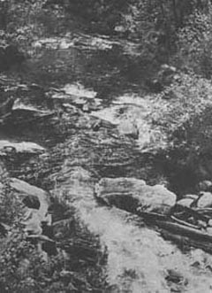
Trout famous Santeetlah Creek |
Finally all constituents of a modern sportsman's ark were present on the Bald. The repertoire included eight buffalo, fourteen young wild boar, fourteen elk, six Colorado mule deer, and thirty-four bears including nine huge Russian brown bears. Two hundred wild turkeys and ten thousand eggs of the English ring-necked pheasant were brought in. Additional turkeys were purchased by Moore and scattered about the mountain in an effort to get them started. Of all these species introduced, only the wild boar adapted itself to the new environment.
Moore himself soon became disenchanted with the Hooper Bald project and moved to Monterey, California. The Snowbird Mountains proved ideal for wild boar, and the boar discovered early that they could root their way out of the split rail enclosure to freedom any time. They remained and multiplied until in 1920 they were about one hundred in number. The big bear learned to climb out of the stockade to search for food. Local poachers soon exterminated the turkeys. The buffalo did poorly, eventually being driven to Andrews and disposed of. The Elk thrived and even multiplied, but ultimately were sold, too. The location proved to be too remote for the genteel Englishmen or anyone else. The venture was ill-fated. By the mid 1920's only Cotton McGuire, the respected old man of the mountains, remained. McGuire had been keeper of the preserve since its beginning and following the departure of Moore had been given full ownership.
The wild boar meanwhile had spread throughout the rugged mountains between Robbinsville and Tellico Plains. Word spread through hunting circles of the vicious fighting boar and sportsmen came from far and near. Fred Bruckmann built Blue Boar Lodge in the Snowbird Mountains and began to organize and promote boar hunts. By the time Bruckmann reached old age he had become a legend as a wild boar hunter. Following the retirement of Bruckmann, Robert Senior of Ohio and Florida purchased the hunting lodge. Senior and his son-in-law Jack Jackson continued to give new life to boar hunting in Graham County. Senior, the Orrs, Phillips, Birchfields, and others have made Graham County the boar hunting capital of the nation.
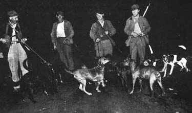
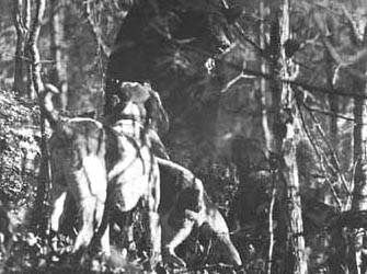
Hunters and their dog pack
|
Hunting party at Patton Cabin on Big Santeetlah
|
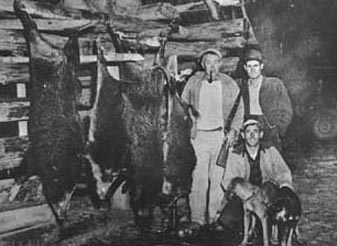
Gwyn Denton, Newt Hooper, and Glenn Rogers show off their catch |
A black bear at bay on Santeetlah |
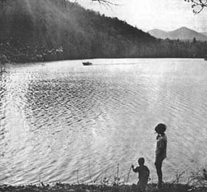
Although not as well publicized, Graham County also has its share of bear, deer, raccoon, squirrel, etc. Likewise from every mountain gush branches that combine into picturesque creeks, many of them trout-famous. Santeetlah creek and others are rated as among the best trout streams in the state and nation. Lake Santeetlah is hailed as one of the best fishing lakes in the county especially noted for small mouth bass, pike, and crappie.
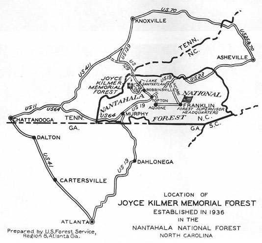
JOYCE KILMER MEMORIAL FOREST
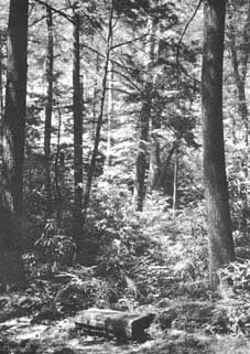
Deep in the mountains of Graham County lies a 3,800-acre tract of the most beautiful forest in America, unmarred and undefiled by the hand of man. On July 30, 1936 the area was dedicated to the poet Joyce Kilmer as a living memorial. It was the simple but beautiful words of Kilmer in the Poem "Trees" which prompted forestry officials and friends of nature to set aside the acreage that now comprises the Joyce Kilmer Memorial Forest. Notice was served to the world that the exploitation and desecration of our forestlands had come to an end.
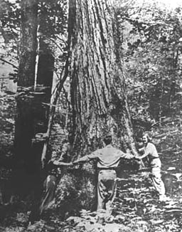
Because of its relative isolation until recent years, the wooded area had remained untouched by the woodman's axe. Huge poplars, some 20 feet in circumference, tower 125 feet or more toward the sky. Giant red oaks, magnificent hemlocks, and many other varieties of trees stand as proud neighbors to the mammoth poplars. The forest, once an isolated region known only to the few who penetrated its boundaries as Poplar Cove has now become an attraction to thousands. The government has set aside the area to remain a "natural area" and maintains trails leading to various points of scenic or botanical interest. One trail leads across Little Santeetlah Creek into Poplar Cove where a bronze plaque placed upon a granite boulder states simply:
"Joyce Kilmer, 165th Infantry, Rainbow Division, Soldier and Poet, Author of "Trees." Born in New Brunswick, N.J. December 6, 1886. Killed in action in France July 30, 1918."
The natural forest was dedicated on the eighteenth anniversary of Kilmer's death in France during World War I. The Bozeman Bulger post of the Veterans of Foreign Wars sponsored the action authorizing the establishment of the Joyce Kilmer forest memorial. As the nature lover strolls by the misty waterfalls through the verdant vegetation, near the flowing cascades, or over the bold, sharp peaks, a beautiful tree will call to mind with renewed freshness and meaning the words:
|
Joyce Kilmer, author of "Trees." |
Another trail follows Little Santeetlah Creek to a trail on top of the Unicoi Mountains. From here a trail follows the ridges to Stratton Bald, Hayoe, and Hangover Mountains. The boldness and grandeur of nature along these trails cannot be matched anywhere. More and more city dwellers from afar seek a few hours of the serenity and tranquility of this natural wonderland.
THE U.S. FOREST SERVICE IN GRAHAM COUNTY
by William L. Nothstein
Graham County residents probably had their first contact with a representative of the United States Forest Service when James Denman came to survey the boundaries of the Olmstead Tracts on Santeetlah, West Buffalo, Big Snowbird, and Little Snowbird Creeks. Retired Forest Service Forest Engineer Lewis H. Mielke was an assistant. This was during the 1920’s when there were few, if any, trails to the neighborhood of these lands. Local residents, typical of the rugged woodsman for whom Graham County is noted, were employed as crewmembers. Some of them, namely members of the Hooper, Huffman, and Martin families, later became regular Forest Service employees in other locations.
The Olmstead Tracts were of varying size and widely spaced. Title to some was not clear. Grant and entry lappages existed. Protection against fire and trespass were needed. For a time, custodial responsibility was placed with the Pisgah National Forest Supervisor in Asheville rather than with the Nantahala National Forest Supervisor at Franklin. Even though Franklin was much closer, travel from Asheville by railroad was more dependable than Model-T Ford transportation from Franklin over poor wagon roads.
Joyce Kilmer Memorial Forest |
Hikers in Joyce Kilmer Forest |
In 1930 District Forest Ranger Z. B. (Zeke) Byrd established an office in Andrews. Previously R. F. Hemingway had maintained headquarters for his acquisition party in the same town. Lands were being purchased on the Valley and Nantahala Rivers. The late Percy B. Ferebee was a Forest Service surveyor at Andrews in 1912. W. Neville Sloan, of Franklin, started surveying for the Forest Service in the fall of 1911.
Ranger Byrd became the custodian of these lands and the Olmstead Tracts. His assistant was the late C. Garland Wilhide. Typical of the loyalty which existed is Wilhide's action when he missed his ride back on the logging train from the junction at Owl Camp Branch, after a hard day of scaling logs sold from an Olmstead Tract. Rather than miss his appointment with Ranger Byrd the next day, he walked to Robbinsville and then drove to his home in Andrews. The meeting took place on schedule.
Joseph Bernier replaced ranger Byrd in 1935. By this time the Civilian Conservation Corps was underway. Camp NCF-24 was established on the Massey Branch Road, beside Lake Santeetlah. More money became available for the purchase of lands. The economic depression continued to be severe. Many good capable men needed a way to earn a living. Wages were low. Land was cheap. Often bread was scarce. Even so, people could leave home for the day, doors unlocked without fear of robbery.
Many young men were glad to enroll in the C.C.C. for one dollar a day plus clothes, keep, and medical care. Older, experienced men competed for the 17 Local Experienced Men (LEM) training jobs paying $36.00 to $45.00 a month plus keep. Project Superintendent A. M. Dietz had a few construction foremen, like C. P. Sawyer and John Earwood, along with young foresters to supervise jobs.
These jobs materialized as purchased land became available. Such tracts were surveyed under the supervision of the late J. Roane Bradley of Franklin. Graham native Gwyn Denton was a transitman. Timber cruising and land evaluation were under the supervision of the late John Wasilik of Franklin.
William L. Nothstein replaced Bernier as District Ranger in November of 1935. There were as yet no lookout towers, telephone lines, or improved trails. Improvement of the Tatham Gap Road (Trail of Tears) was underway with the Topton C.C.C. Camp on the Cherokee side and the Robbinsville Camp on the Graham side. Graham County was free range and for generations people had believed forest fires improved grazing. Timber had little value and it was sometimes cut as needed.
Changing the thinking and habits of a proud, free, and independent people required diligence, tact, and diplomacy. Local influential Graham County residents are responsible for changing old customs and practices for those in keeping with Forest Service policies. Such men as R. Bruce Slaughter, R. B. (Bob) Phillips, T. M. (Ted) Jenkins, Col. T. A. Morphew, L. W. Wilson, Dee Jordan, Forest Denton, Baxter Campbell, Patton Phillips, Ed Ingram, Wayne Wiggins, Victor Denton, Grant Stewart, Gurley Stewart, Joe Wilson, Garland (Cotton) McGuire, Oliver Collins, Charlie Hooper, Oliver Martin, Albert and Jim Huffman, Blake and Grady Lovin, Gaffney Long, C. A. Bales, Nelson Higdon, Dan Gladden, Cecil Rice, Jarrett and John Wayne Wachacha, John Orr, Pat Orr, Dee and Marion Carringer, Elbert Wilkey, Roy Milsaps and his father, and a number of sheriffs. John Shuler, Bill Phillips, Gardner and Nath Burchfield, the Odoms, Arvil Adams, Will Cooper, John A. Rogers, the Hedricks, Dan Ghormley and his father, Mike Brown, the Garlands, Roy Sherrill, the Crisps, Hydes, Nelms, Brewers, Carvers, Moodys, Cooks, Greens, Williams, Cables, Princes, Codys, Holders, Carpenters, McClungs, Davis, Haneys, Edwards, Elliotts, Howells, Walter West, J. J. Dula, Ross Holland, the Buchanans, Will Sherrill, Bruce Lewis, and others supported Forest Service programs.
With such support and influence, much progress was made. Citizens requested the establishment of the Santeetlah Wildlife Management Area. Before this could be done, livestock ranging in the area had to be stopped. All users of this range agreed to move stock elsewhere within two years. They did so without protest. Young deer, recently weaned, were brought in from the Pisgah National Forest. Early in 1940 C.C.C. enrollees back-packed 8,000 brown trout to Slickrock Creek through Yellow Hammer Gap with a known loss of only three fish.
Forest fires were generally confined to a few trouble spots east of Cheoah River. A metallic circuit telephone line (two wires on poles) was built from Camp F-24 to Andrews with a spur to a new lookout on Joanna Bald. Another temporary lookout was built on Hayoe and connected to Camp F-24 with a ground circuit (one wire on trees). No horses or vehicles were used on these jobs. C.C.C. enrollees carried material from the nearest road. Timber stand improvement and tree planting were started. Trails were dug with mattocks. A road to Santeetlah Creek was built.
Graham County received nation-wide publicity when the Joyce Kilmer Memorial Forest was dedicated in July of 1936. Since then it has continued to be an attraction to visitors from all states and several foreign countries. Even Adolph Hitler probably learned about it from 30 German foresters who visited there shortly before America entered World War II.
That war caused a great change. C.C.C. enrollees and some of their foremen entered the Armed Forces. The camp was closed. Forest Service work was limited to fire protection and the sale of forest products needed to win the war. In August of 1943, Nothstein was succeeded by John Stanley who remained at the Andrews station until the war was over. He was replaced by John J. Olson who later became the first Graham County resident District Forest Ranger when a home was built at the site of Camp NCF-24. Previously, the Tennessee Valley Authority had completed Fontana Dam. Most of the lands adjoining the reservoir, in Graham County and some in Swain County, were transferred to the Nantahala National Forest. More appropriated funds made it possible for the 28,000 acres of Whiting Manufacturing Company lands to be added to the Cheoah Ranger District. National Forest lands were then located in all sections of Graham County.
The stage was now set for the development and management of a large block of natural resources for and by the American people. Space does not permit a record of activities during the tenure of individual succeeding District Forest Rangers. Many Graham County citizens were employed in developing facilities and protecting the forest. In addition to fires there was serious damage to timber by the elm spanworm in the sixties. This damage was second only to the destruction by the chestnut blight that killed all trees of that species. The Joyce Kilmer Memorial Forest was sprayed from the air to protect trees against the spanworm. Elsewhere, oaks and hickories suffered severe mortality. Timber sales provided local employment and a road system for access to areas of use and enjoyment. Radios replaced telephones. Aircraft are now used to detect fires and to check them with retardants dropped from aloft. Jeeps have eliminated much hard walking and climbing. A modern ranger station, with office, warehouse, two residences, a boat-launching site, and other facilities, has replaced C.C.C. Camp NCF-24. This station is now on a paved highway. Twenty-four and 36-hour shifts on the fire line have become history.
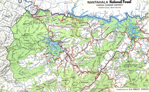
Lake Santeetlah with its shoreline of 126 miles
Recreation is now a major activity. Boat launching sites have been developed on lakeshores. Backpackers from distant parts use the Appalachian Trail. Improved campgrounds at Horse Cove, Cable Cove, Cheoah Point, and Tsali attract many people. The European wild boar has brought in hunters. Trout fishing ranks with the best in the east. New roads offer more scenery to the motorist. Fontana is a major resort.
Contributing to these developments and improvements have been the following District Rangers:
| Walter J. (Wally) Gray, January 1951 to September 1953 |
| E. M. (Eddie) Manchester, September 1953 to July 1954 |
| Earle A. (Preach) Parson, July 1954 to August 1961 |
| Thomas L. (Tom) Thrash, August 1961 to September 1964 |
| Thomas L. (Tom) Price, September 1964 to November 1967 |
| Charles D. (Charlie) Aulds, November 1967 to June 1971 |
| John A. Derks, June, 1971 |
As the resources and facilities of the Cheoah Ranger District became better known and available, they attracted more people. Each group wanted preference and priority for its favored activity. Some conflicts developed. Controversies are indicative of national interest in Graham County attractions. In time, they may be viewed as fortunate since they should lead to the best possible solutions for the benefits of most people. Good management and wise use of National Forest resources will provide Graham County with a sound economic base for the future. May its citizens always be happy with freedom, space, clean air, clean water, and a respect for nature.
Title to Swan Meadows
Click map for a larger view